Coastal Zone Management
“Coastal waters” include the sea, and those waters adjacent to the landward line of adjoining land or connected permanently or intermittently with the sea which contain a measurable quantity of seawater, sounds, bays, lagoons, ponds and estuaries, and the land below and along the banks of the waters.
“Coastal zone” means any area having an elevation less than 15 metres above mean sea level within a limit of one hundred metres of the mean high water mark and a limit of two kilometres seawards of the mean low water mark and shall include the foreshore and the floor of the sea.
Coastal Zones have significant value for all life globally and provide shelter, food and even leisurely entertainment. Beaches are one of the most dynamic and fast changing environments in nature. They can change significantly in a matter of hours. In the islands of the Eastern Caribbean the coastal zone, which includes beaches, where much of the islands’ infrastructure, tourism, and industry is concentrated. For these reasons, planners need to understand, and be able to predict, how the beach is likely to change in both the long and short term.
Frequently-Asked Questions
Funds Raised
0k
Trust Score 4.7 (Based on 1,200 reviews)
How it’s done:
Beach profiling measurements are conducted along profile transects. The profile transect is a straight line running from the crest of the dune or other high point on the beach (such as a seawall) to the waterline. Along the transect, measurements are taken every three meters allowing observations of the beach to be made. Each monitored beach has between two and seven profile transects. And each transect has a different number so that comparisons can be made between these various lines.
Why it’s done:
Comparing profile lines recorded at different times makes it possible to measure changes in the distribution of sand on the beach. Tracking these changes over long periods provides data to identify seasonal, annual, and even track long-term trends in beach erosion and accretion. This data is used to inform beach management decisions at a national level and the data is shared with the
When and where it’s done:
Every month members from the Department of Environment changes in sand movement along seven beaches on the South East Peninsula.
Coastal zone monitoring and also beach profiling is mainly carried out to examine the effects of natural and manmade processes. Examining and recording the profile of a beach allows you calculate certain thing such as the gradient and even shape of that beach area.
There are two main factors of coastal area change; erosion and accretion. Erosion can be defined as a physical removal of sand from the beach which is transported offshore, alongshore, or into bays and lagoons via inlets. Erosion results in shoreline recession Given the stresses being placed on beaches both by man (increased development, sand mining) and by nature (global warming and sea level change), long term changes in these areas will most likely be towards more erosion.
Deposition of sediment, usually sand, which is evident by the seaward advance of a shoreline indicator, such as the high water line, berm crest, or vegetation line. Accretion causes the beach to become wider. Opposite of Erosion.
Accretion begins with sand deposition on shore, from the movement of the waves, tides and longshore current. Some sand is then dried out by the wind and sunlight, allowing it to be blown to other areas of the beach by the prevailing winds. Sand is the major component in accretion/erosion cycles. Sand is sourced from weathered or eroded material along the shore or from inland areas, carried to the shore by rivers. Sand can also come from corals or shellfish.
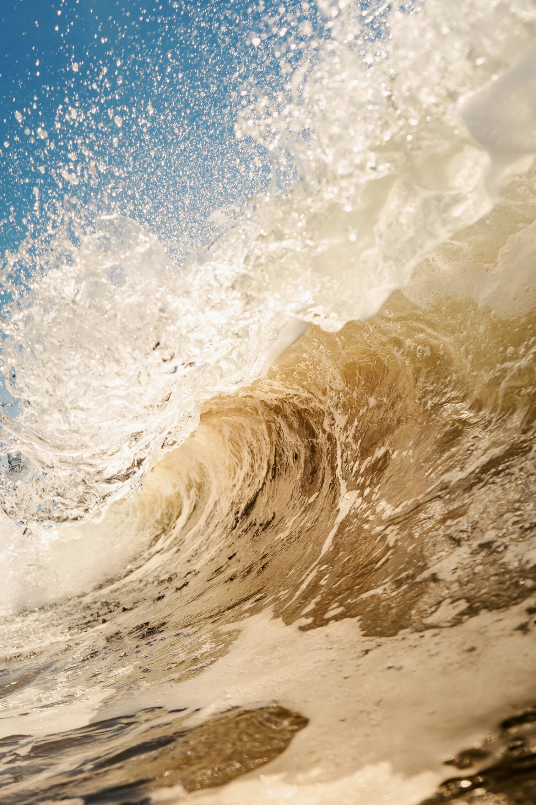
Wave action plays a significant role in the formation of a beach. Waves can assist in both the deposition (accretion) and erosion of a beach. In calmer weather, the wash of the waves deposits sand onto the shore while the backwash removes small amounts of material. The amount deposited is typically greater during this time. During more unsettled conditions, such as storms and periods of large waves, removal of material is much higher.
Coastal monitoring also includes other measurements like water quality, cliff retreat, dune measurements, vegetation surveys and grain size analysis.
Due to St. Kitts mainly being a coastal community and is also heavily invested in eco-friendly tourism. This mean that we must try our best to not only protect the coastal environment but also become aware of all the factors whether terrestrial, marine or manmade that has an effect on coastal zone and determine best ways to assist and increase the positive effects and find more low impact ways to mitigate the negative effects.
What is pollution?
POLLUTION is defined as any destructive or potentially destructive material that is introduced into the environment.
Where does beach pollution come from?
- Solid Waste such as picnic plates, plastic bags, bottles, and cigarette butts that are left behind by people.
- Aging sewage treatment plants.
- Storm water runoff
- polluted runoff from farms, roads, and cities.
- Accidental oils spills
Studies have shown that beach pollution is usually infrequent and confined to local areas. Problems can develop in areas near pollution sources after a heavy rainfall. Pollution can also occur from disruption or damage to wastewater collection and treatment infrastructure due to severe natural events such as hurricanes or floods, illegal dumping, accidental oil spills, and solid waste trash left behind by people.
- SOLID WASTES
- Plastic, rubber, foam materials, and metals take hundreds of years to break down. Animals are sometimes killed by the ingestion of plastic, rubber, or foam that they have mistaken for food. Some animals drown from entanglement, others are choked by plastic rings.
- SEWAGE AND SEWAGE TREATMENT
- A mixture of human generated waste is dumped into the oceans from sewage treatment plants that are not able to handle the load that is routed through them. This leads to partially treated or untreated sewage sludge being dumped into the water.
- Sewage sludge is made up of organic waste containing bacteria, viruses, poisonous compounds, synthetic and organic chemicals, and an overabundance of nutrients.
- POLLUTED RUNOFF FROM FARMS, ROADS, and TOWNS
- This is runoff that goes into sewer system or just makes its way directly into the water system. Much of the pollution comes from illegal dumping of household and industrial chemicals, automobile waste, and agricultural chemical and fertilizer usage.
- ACCIDENTAL OIL SPILLS
- This encompasses oil spills from ocean going tankers, offshore drilling, and illegal dumping
What are the major problems caused by beachfront pollution?
The most obvious problems are aesthetic ones. No one likes to go to the beach and see trash lying all over the area. Other problems come from the destruction of the habitats of the organisms that call the beachfront home as well as the actual “killing off” of the organisms with oil spills, solid waste trash (plastics, metals, etc), chemicals, etc.
Significant problems also arise from things that we cannot see, these are microorganisms. Many harmful microorganisms (viruses, bacteria, protozoans) are released into the ocean through untreated or partially treated sewage.
These organisms pose a serious problem in that people with weakened immune systems (children, elderly) can develop illnesses or infections after swimming in polluted water.
Swimming related illnesses are typically minor. The most common illness associated with swimming in water polluted by sewage is gastroenteritis. It occurs in a variety of forms that can have one or more of the following symptoms: nausea, vomiting, stomachache, diarrhea, headache, and fever. Other minor illnesses associated with swimming include ear, eye, nose, and throat infections. In highly polluted waters, swimmers may occasionally be exposed to more serious diseases such as dysentery, hepatitis, cholera, and typhoid fever.
Creating a monitoring Program
In order to set up a Coastal monitoring programme, you need to make certain decisions and prepare certain materials, you need to:
- Decide how many beaches can be monitored
- Identify problem beaches
- Prepare location and reference sheets
- Develop a schedule for taking samples and running lab tests.
Due to St. Kitts mainly being a coastal community and is also heavily invested in eco-friendly tourism. This mean that we must try our best to not only protect the coastal environment but also become aware of all the factors whether terrestrial, marine or manmade that has an effect on coastal zone and determine best ways to assist and increase the positive effects and find more low impact ways to mitigate the negative effects.


